1. Get your spatial data ready. If you’re just starting to work with spatial data and don’t have a handy .shp file, you can visit some of these sites which provide publicly available shapefiles:
http://www.vdstech.com/map_data.htm
http://wwwn.cdc.gov/epiinfo/script/shapefiles.aspx
http://www.mapcruzin.com/download-free-arcgis-shapefiles.htm
http://www.census.gov/geo/www/cob/bdy_files.html
2. Download the SQL Server Spatial Tools from ArcGIS, which include the Shape2SQL tool.
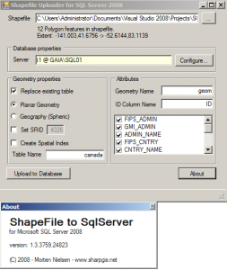
3. Once downloaded, launch the Shape2Sql.exe file.
4. Fill in the fields required for database, table etc. However DO NOT check in the “Create Spatial Index” (as of Version 1.3.3759). It seems that when you click on this, the table does not get created in SQL Server.
5. Check your database, you should now have the new table you’ve specified in Shape2SQL, which contains the spatial data included in your shapefile.
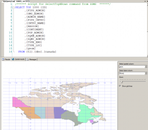
6. If you select the data from this table in SQL Server Management Studio, you should see a new result tab called Spatial Results once you execute your query:
How to Import Shapefile (.shp) Spatial Data into SQL Server 2008,


Thanks for the list of publicly available .shp files-I definitely want to play around with this!
I want give border to shape file or give to background image.
can it possible.
reply..
Shape2Sql.exe to be a cool application but it doesn’t work in my case : i try to upload into a SQL Server 2012 Express 64bits and it doesn’t work. Is there another possibility (script…) to import a shape fill in sql server ?